Oh yeah, winter 17/18 definitely had a very stable snowpack. So it was obvious we had to put it in good use with a special run at the Arlberg, the Valluga. Every good skibum there has to ride the legend at least once. Why it took us 5 years is explained quite easy: Every time we set a date to do it, an avalanche occoured, some with fatalities. Admittedly always on the north face, but it gets you into thinking, if you really need to do this. And the seasons 15/16 and 16/17 were out because of the weakest weak layers on the north faces.
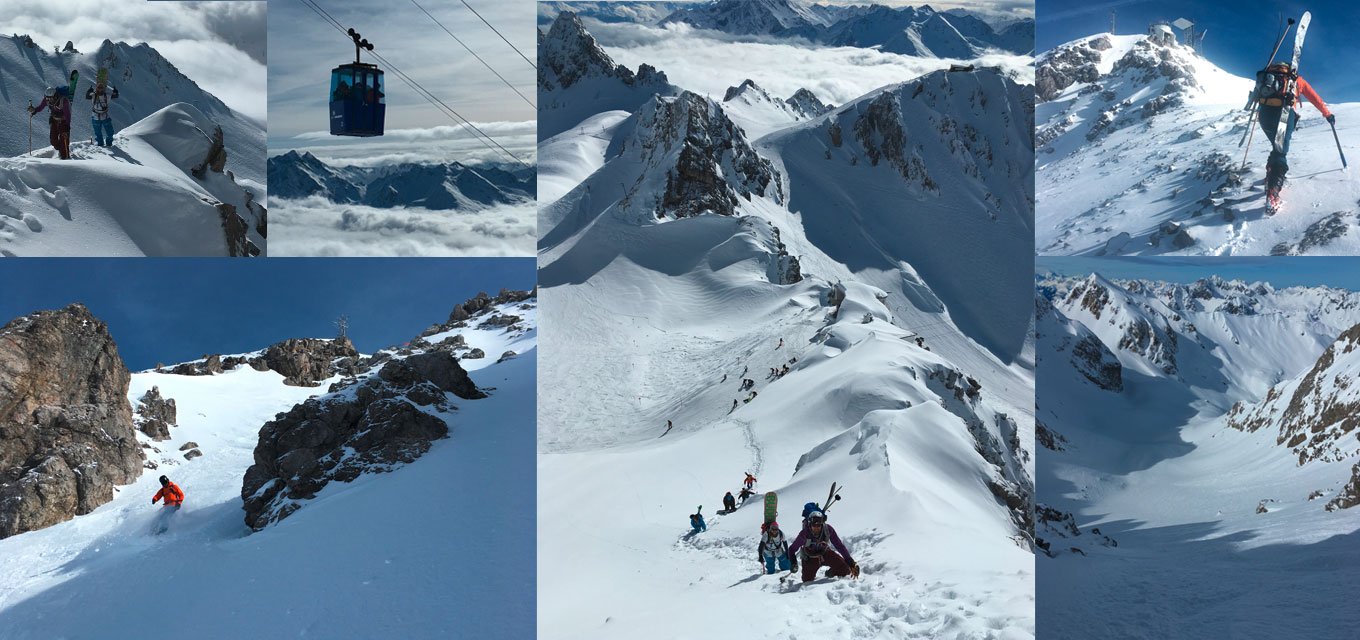
At 2.809 meters the Valluga is the highest lift-assisted peak at the Arlberg, sitting exactly on the boarder of Tyrol and Vorarlberg. The catch is, that you can only take yours skis up with the Valluga II Gondola, if you’re in the company of a professional mountain guide. Otherwise you have to leave your skis behind, if you only want the view. Or, like we did, hike it up. The bootpack is not that hard (20-30 minutes, only 150 meters up), but the downhill should not be underestimated.
Starting point of our tour was the summit station of the Vallga I Gondola. We left the building in direction of the Vallugagrat slope and put on our gear just some steps further on the left. As it is a steep bootpack, we put the crampons on our boots and attached the skis to the backpacks. I also like to use an ice axe as it is more convenient than a pole. Although I don’t own an ice axe, I can convert my Ortovox snow shovel into one. I always carry the little mount in my backpack. Very handy at times…
That said and done, we started our hike up, staying on the left (not to the station on top), using the summer hiking track in a north-west direction, which you can find online at outdoor-active. Sometimes there’re old footsteps visible you can follow. Above we reached a plateau which relaxed me tremendously (still afraid of heights here…). If you take a path a little further left, there’s a ridge with spectacular views down the abyss… yay. Now we just had to walk – in part along a steel rope – a little further up to the bridge, where we found the easiest access to the downhill. There’re of course many more varieties to ski down, all depend on the snowpack. We had a snowboarder in our company and for him it probably would’ve been better to walk down the entry under said bridge, because it’s quite narrow and rocky. No fun with a board. Right after that narrow piece the slope got wider and the turns got easier. We kept going straight through the large cirque in western direction of the Trittkopf peak and only then turned right into the Paziel Valley. We’d chosen that route because of the snowboarder, so he’d be able to traverse and not to walk back to the resort. As I said, there are different routes down. We traversed a long way and tried not to lose too much height along. We made it right to the slope no. 122, which ends up at the Trittalp chair-lift at Zürs.
If you don’t know the area or don’t like to earn your turns, you can always hire a guide, that takes you up on the gondola.
Share this Post